Significant Storm This Weekend
Thursday Morning Update —
Confidence is increasing this morning for a potentially significant rainfall event this weekend across NW Oregon and SW Washington. A strong September jet stream will consolidate across the Pacific Ocean and aim its energy at the Pacific Northwest beginning Friday night and lasting through the weekend. This is fairly significant by September standards and would be something we would expect to see later in the fall or winter months. The most significant of these systems will arrive Saturday night. Remnants of a tropical typhoon will be entrained into the jet stream which will help add to the precipitation rates across the region. Latest model data out this morning shows the continued trend for potentially significant rainfall amounts across the central and northern Oregon coast, the coast range mountains, the northern Oregon Cascades and interior valley locations of NW Oregon and SW Washington as the system stalls over these areas Saturday night. If model trend data verifies, there is the potential for 72 hour rainfall amounts to exceed 6″ in the mountains and nearing 3″ in the valleys come Monday morning. This comes on the heels of a very wet September already. The Portland International Airport has received 2.24″ of rainfall to date which is more than 1″ above average for September. The wettest September on record at the airport was in 1986 when 4.30″ of precipitation fell. Period of record is 1940-Current. If model forecasts are correct, Portland may challenge the top spot by the end of the month Monday. The focus of this weekends system will be rainfall, and lots of it. I will post further updates here on the blog if anything changes substantially. Feel free to hyperlink to this blog. Get ready for another wet and wild ride this weekend!
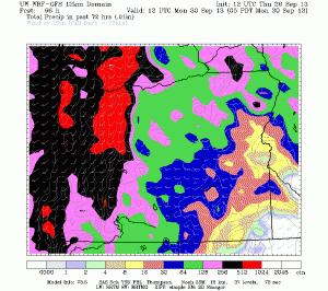
Here is a the latest U of W WRF model showing 72 hour rainfall map ending at 5am Monday. This would be significant by September standards. For instance, the red color is rainfall totals between 5-10″ in the northern Oregon Cascades and areas of the northern coast range.
Stay tuned!
Steve Pierce
President, Oregon Chapter of the American Meteorological Society (AMS)
Columbian Newspaper Weather Blogger
The Oregon Chapter of the American Meteorological Society (AMS) will host the 21st annual Winter Weather Forecast Conference on Saturday, October 26th 2013 beginning at 10am at OMSI in Portland. This annual meeting is the single largest conference of its kind in the Pacific Northwest! Weather forecasters from across the region will once again converge on Portland to give their best prognostications for what this upcoming winter will bring weather-wise to Oregon and SW Washington. This meeting is also free and open to all ages of the general public. Please arrive early if you want a seat. We will also raffle off a $300 Davis home weather station to one lucky winner. This meeting normally attracts a capacity of 300+ attendees. To view complete details on this meeting please see: http://ametsoc.org/chapters/oregon/MeetingInfo/2013/2013_10_26_OR_AMS_Meeting_Announcement.pdf
Don’t forget — you can get my latest weather and climate updates via Facebook. Send me a friend request at http://facebook.com/stevepiercevancouver and I will add you in. Don’t forget to also bookmark this blog at http://blogs.columbian.com/weather. Are you an amateur simply interested in weather? Maybe you are a professional meteorologist? Why not join the single largest chapter of the American Meteorological Society (AMS) in the country with 180 fellow members? The Oregon chapter hosts eight monthly meetings from September through June. All of these meetings are free and open to the public. We are always looking for new members. Dues are just $10 a year! For Oregon AMS meeting details and a membership application, please see http://ametsoc.org/chapters/oregon


